
12
-
![[Création du parc de la Tête-d'Or : vue générale sur le site, avant le commencement des travaux]](https://numelyo.bm-lyon.fr/BML:BML_01ICO001014cca7e964a885/thumbnail_Source0.jpg) [ca 1855]
[ca 1855][Création du parc de la Tête-d'Or : vue générale sur le site, avant le commencement des travaux]
Vue prise en direction du nord-est depuis la colline de la Croix-Rousse, vers 1855. Sur la droite : une partie du quai d'Albret, actuellement quai de Serbie, l'avenue du Parc, actuellement avenue de Grande-Bretagne, et le boulevard d'Enceinte, actuellement boulevard des Belges. Au fond, sur la gauche : le viaduc du chemin de fer enjambant le Rhône. -

-
 [19..]
Lyon. - Le Monument des Enfants du Rhône. - Le Pont de la Boucle et le coteau de St-Clair
Inscription(s) sur l'image : "B. F., Paris". -
 [avant 1913]
Lyon. - Panorama du Parc de la Tête-d'Or et le Pont de la Boucle
Inscription(s) sur l'image : "LL.". -
 [avant 1913]
Lyon. - Panorama du Parc de la Tête-d'Or et du Pont de la Boucle
Inscription(s) sur l'image : "LL.". -
 [19..]
Lyon et ses environs vus en aéroplane - St-Clair - Pont de la Boucle - Lac du Parc - Pont Morand
Inscription(s) au verso : "A. Bordet & Cie, Edit. Lyon - Photo J-M Rodet, sur aéro piloté par Plantier". -
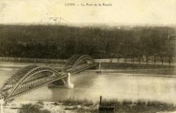 [avant 1904]
Lyon. - Le Pont de la Boucle
Inscription(s) sur l'image : "Carrier, édit. Déposé". -
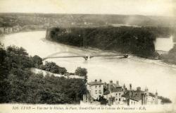 [avant 1919]
Lyon. - Vue sur le Rhône, le Parc, Saint-Clair et le Coteau de Vassieux
Inscription(s) sur l'image : "E. R.". -

-
 Collection inconnue [19..]
Lyon. - Panorama du Parc de la Tête-d'Or et le Pont de la Boucle
Inscription(s) sur l'image : "168. Lyon - Panorama du Parc de la Tête d'Or et le Pont de la Boucle - LL.". -
-
 [avant 1929]
Lyon. - Pont de la Boucle et Vue sur le Parc
Inscription(s) sur l'image : "E R.".